-
The weather data experts.
-
We're here to help
info@advectweather.com
Simply the easiest way to get
the weather data you need
It's all here
A single interface to the world's weather
Weather services around the globe disseminate hundreds of high-quality weather datasets every day. Global and regional forecast models, radar and satellite data, station observations, air quality measurements - it's all made publicly available.
The difficulty lies in first locating the data, and then knowing how to interpret it. Most data is stored in compressed binary files which require specialized software to read, limiting your options in how you can interact with the data. Advect addresses both of these issues, allowing you to quickly locate the data you need and retreive it in user-friendly formats such as CSV for easy import into your preferred analysis tools.
Built with a purpose
Advect was designed around one core idea: Get usable weather data into the hands of those who need it, and this idea extends beyond the platform itself. The Advect team has decades of experience building storage and analysis tools for weather data and we're here to help in whatever capacity works best for you. From showing you how to import data into Excel and generate charts, to helping you set up your own cloud storage and analysis resources, to architecting and building an entire system for you, getting you the data you need is only half the job - the other half is ensuring you can use it.
Become extremely popular with your IT team
When a product or service relies on weather data, it usually needs that data to be constantly updated as new forecasts and observations become available. Just getting automatically recurring updates up and running stably can require a significant amount of development and monitoring time, not to mention subsetting, reformatting, and storing the data once you have it. Advect handles all of that for you. Just choose the data you want, where and how you'd like it to be delivered, and let your IT team focus on building the next great weather product.
-
No development
-
No maintenance
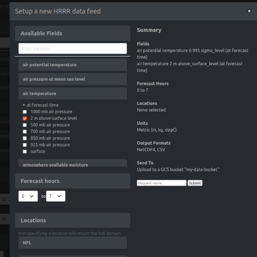
Get your first data feed up and running in 3 minutes
No kidding! In less than 3 minutes you can have a customized, continuously updating data feed pushing forecast, satellite, radar, or observation data to you. Whether it's 300mb winds from the HRRR model as a CSV, composite reflectivity images from MRMS, or GFS surface temperatures over Angola in degrees Celsius delivered in netcdf format, you're just a few clicks away from getting exactly the data you need.
Priced For All


Basic
Students and hobbyists
$49
-
Installation
-
Repair & Replacement
-
Monitoring
-
Panel Maintenance
-
24/7 Support
Advantage
Research and Startups
$279
-
Installation
-
Repair & Replacement
-
Monitoring
-
Panel Maintenance
-
24/7 Support
Pro
Commercial Users
$499
-
Installation
-
Repair & Replacement
-
Monitoring
-
Panel Maintenance
-
24/7 Support
Enterprise
Custom Setups
Contact Us
-
Installation
-
Repair & Replacement
-
Monitoring
-
Panel Maintenance
-
24/7 Support